Ouray Perimeter Trail 
Distance: 5.9 miles
Uncompahgre National Forest, near Ouray in Southwest Colorado
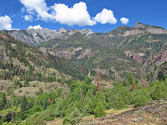
View from the high point
Ouray’s scenic Perimeter Trail circumnavigates the town by traveling along cliffs, canyons and forested hillsides. Along the way the trail passes points of interest including Cascade Falls, the Baby Bath Tubs, the Amphitheater, the Uncompahgre River, Canyon Creek and some beautifully restored Victorian homes.
- Distance: 5.9 miles (Loop)
- Elevation: 7,680-ft. at Trailhead
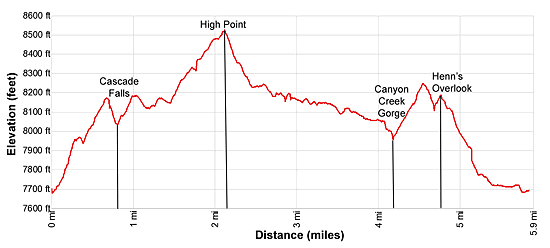
Maximum elevation - 8,530-ft. - Elevation Gain: 850-ft.
- Difficulty: moderate
- Basecamp: Ouray
- Region: Southwest Colorado
Trail Description - Ouray Perimeter Trail
The Perimeter Trail offers a good perspective of the Ouray area and is a nice option if the weather is taking a turn for the worse in the high country. The path is accessible from a number of points around the town, permitting the trail to be cut short or done in segments. Connections with other town trails offer interesting ways to extend a hike or use segments of the trail to create scenic loops. Maps and trail descriptions are available at the Ouray Visitor Center, adjacent to the Hot Springs
The easiest place to start the Ouray Perimeter Trail is at the Ouray Visitor Center, located at the north end of the town adjacent to the Ouray Hot Springs. (See driving directions below.) From the Visitor Center cross to the east side of the Main Street (Highway 550) to a map located next to a large boulder. The trail now heads northwest, passes behind the Skyrocket Townhomes and then ascends a steep wood staircase.
Soon the trail turns right, heading south/southeast, as it ascends along cliffs toward Cascade Falls. As you climb pass the historic Two Kids Mine and enjoy terrific views of Ouray and the rugged peaks towering above the south and west sides of town. Views encompass Twin Peaks, Whitehouse Mountain (13,452-ft.), Mount Abrams (12,801-ft.), Hayden Mountain (13,139-ft.) and U.S. Mountain (13,036-ft.). Portions of this trail are exposed and may cause discomfort to people with a fear of heights.
At 0.6 miles the trail starts a brief descent that leads to lovely Cascade Falls at 0.7 miles. The falls is the lowest of a series of seven waterfalls on Cascade Creek. After crossing a bridge below the falls the trail enters the trees and climbs steeply up the Lower Cascade Trail. At 0.9 miles reach a junction where the Perimeter trail turns right while the Lower Cascade Trail bears left up the hillside.
The Perimeter trail now follows an undulating course along the slope beneath the Amphitheater Campground. Openings in the trees offer more great views of the high peaks to the south and west. At 1.2 miles cross the 5th Avenue Trail which offers another option for leaving the trail and returning to town.
Beyond the junction the trail enters the trees and ascends a short distance to the paved Amphitheater Campground Road. Turn right and follow the road for 0.1 miles. Cross the road at 1.5 miles and find the continuation of the Perimeter trail, which coincides with the Baby Bath Tub Trail for the next 0.3 miles. (If you cross a bridge on the road you have gone too far. Turn around and look for the trail on the south side of the road.)
The Baby Bath Tubs segment of the trail features interesting quartz pools (bath tubs) in the streambed. Along the way the trail crosses Little Portland Creek, and then parallels the creek as it climbs to a junction with the Portland Trail. Turn right here and almost immediately cross a bridge over Portland Creek. Follow the Portland Trail for 300-ft. to a “Y” junction. Here the Perimeter trail bears left and climbs uphill through the Three Pines Day Use Area and forest to the Portland Mine Road. Cross the road and follow the path as it travels through the Potato Patch and reaches the high point of the trail (8,500-ft.) atop a rocky knoll at 2.1 miles.
Below the trail is the dramatic Uncompahgre Gorge. Hayden Mountain towers overhead while Whitehouse Mountain and Twin Peaks dominate the view to the west. The Amphitheater looms over the valley to the northeast.
The descent from the high point is accompanied by great views of Abrams Mountain rising to the south. Reach Highway 550 at 2.4 miles. Carefully cross the highway and then turn left (south) on an old road that reverts to a trail at 2.8 miles. (It is possible the short-cut this section by 0.5 miles by turning right.)
The trail descends to a bridge crossing the Uncompahgre River at 2.9 miles. Cross the bridge and then climb up and cross a stile over a large pipe along a service road (the Ice Park trail). The pipe carries water to the Ouray Hydro-Electric Plant and supplies water to the Ice Park in the Uncompahgre Gorge to your right.
Turn right (north/northwest) and follow the services road for 0.6 miles. Just past a small reservoir bear right on a trail that reaches CR 361 (the Camp Bird Road to Yankee Boy Basin) at 3.8 miles. Cross the road and follow the trail to Box Canyon Falls and Park. A detour to the park (fee required) is recommended if time and energy allow.
Stay left and cross the steel suspension bridge over dramatic Canyon Creek Gorge. On the far side of the bridge travel through a tunnel once used to route an old water pipe and then descend steep stone stairs along a cliff face. Railings and fixed pipe along the cliff facilitate the descent.
Beyond the stairs the trail ascends a hillside to meet the South Pinecrest Road at 4.2 miles. This is another good spot to exit the Perimeter Trail.
Turn left and ascend South Pinecrest Road for 0.2 miles to a signed junction for the Oak Creek/ Twin Peaks Trail and the continuation of the Perimeter Trail. Turn right and follow the trail uphill. Soon you will reach a junction where we bear right to stay on the Perimeter Trail.
Follow the path as it drops steeply into Oak Creek Canyon and crosses Oak Creek on a new bridge. Metal stairs facilitate the climb out of the canyon to Henn’s Overlook at 4.8 miles. The overlook features fine views of Ouary. The Amphitheater, Cascade Mountain, Cow Mountain and Gold Hill rise above the east side of town.
From the overlook the trail descends to Queen Street in Ouray. Head down Queen Street and turn left on Oak Street at 5.25 miles. Head north on Oak Street, passing restored Victorian homes, a campground and trailer park. At 5.7 miles, at the north end of the trailer park, turn right and cross the Uncompahgre River on a bridge. You will now be at the southwest end of the Hot Springs/Visitor Center Parking area.
Elevation Profile
Driving Directions
Driving Directions from Ouray: The official beginning of the Ouray Perimeter Trail is at the Ouray Visitor Center, 1230 Main Street (Highway 550). The Visitor Center is located at the north end of town along the west side of Highway 550 and shares a parking lot with the Ouray Hot Springs. There is plenty of free parking in the lot.
Trail Resources
- Trail Photo Gallery
- Trail Maps
- Basecamp(s) Information: Ouray
- Region Information: Southwest Colorado
- Other Hiking Regions in: Colorado