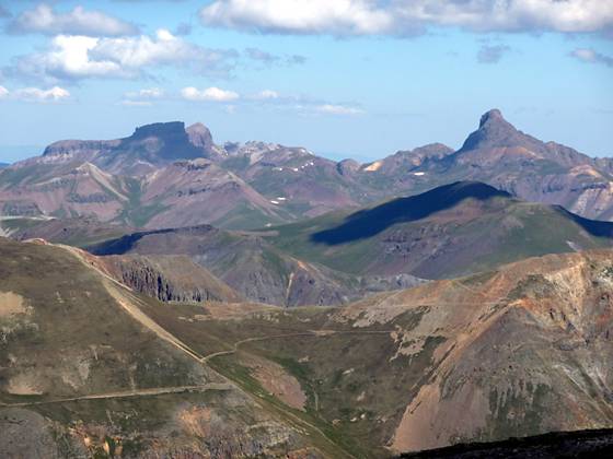
Closeup view looking north from Handies Peak
The top of Handies Peak offers breathtaking views of the San Juan Mountains. This alternative route to the summit is longer and more strenuous but less traveled than the more popular trail to Handies Peak via American Basin.
- Distance: 8.0 miles (RT)
- Elevation: 10,425-ft. at Trailhead
Maximum elevation - 14,048-ft. - Elevation Gain: 3,623-ft.
- Difficulty: killer
- Basecamp: Lake City
- Region: Southwest Colorado
Trail Description - Grizzly Gulch
Grizzly Gulch offers an alternative approach to the summit of Handies Peak (14,048-ft.) that is longer and gains more elevation than the more popular hike to the summit via American Basin. The trail ascends the scenic Grizzly Gulch valley and then climbs the north ridge of Handies Peak to the summit. The pristine valley provides a degree of solitude not usually found on the route up American Basin and the trail is a good alternative for hikers who do not have a 4WD for negotiating the road up American Basin.
The best time to visit the area is late July and early August when the tundra basin below the peak is carpeted with wildflowers. A small alpine lake in the eastern spur of the basin can be reached as an interesting 1/2-mile side trip.
From the trailhead (see driving directions), follow the trail that starts behind the restroom and leads to a bridge crossing the Lake Fork of the Gunnison River. Beyond the bridge the trail heads straight up the valley through spruce, fir and aspen for about 0.75 mile along the north side of the drainage.
The trail now climbs through a series of avalanche shoots interspersed with small groups of trees. At 1.7 miles leave the last of the trees behind and continue the ascent through beautiful meadows with wonderful views of Handies Peak. Soon the trail enters a gorgeous alpine basin and for a brief period follows alongside the creek, crossing it twice. Be sure to look over your shoulder on the way up the basin for beautiful views of the Silver Creek Valley to the northeast.
Just beyond the second creek crossing a sign points right (north) to a long switchback that helps ease the climb up the west side of Handies’ north ridge. The ascent to the ridge gains over 1,225-ft in just under 1.1 miles. Along the way the trail curves to the southwest as it climbs through rocky meadows and crosses a large talus fields. A few switchbacks aid the final stiff climb to the ridge crest.
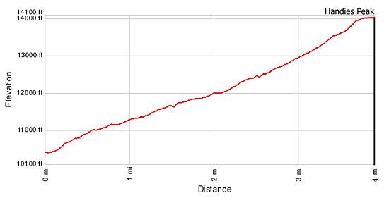
On the ridge the trail heads south, climbing rocky slopes on a series of very steep switchback for 0.2 miles. At the top of the switchbacks the grade abates. The path to the summit is now visible, ascending the ridge crest on moderate grades for 0.2 mile. Reach the top of Handies Peak at 4.0 miles after gaining 3,592-ft.
The panoramic views from the top are some of the best in the area. To the southwest the jagged peaks of the Grenadier Range and Needles Mountains extend to the horizon. To the north are the distinctive summits of the Uncompahgre Wilderness, including Wetterhorn, Matterhorn and Uncompahgre Peaks. To the northeast is the La Garita Range while to the west/northwest the peaks of the San Juan Mountains near Silverton and Ouray, including the Mt. Sneffels Range, fill the skyline.
After taking in the views retrace your steps back to your car. Alternatively combine the Grizzly Gulch trail with the Handies Peak / American Basin trail to create a very scenic 10 mile loop. From the top of Handies Peak take the Handies Peak trail down through American Basin to the main road and back to your car. This 10 mile loop can be done in either direction.
Elevation Profile
Driving Directions
Driving Directions From Lake City: Take Highway 149 south for 2.5 miles and turn right on County Road 30 toward Lake San Cristobal. Follow the paved road about 4.0 miles then continue on dirt road for 12.6 miles. Look for a sign on the left (south) side of the road for Handies Peak. Parking is available in defined areas on both sides of the main road.
Trail Resources
- Trail Photo Gallery
- Trail Maps
- Basecamp(s) Information: Lake City
- Region Information: Southwest Colorado
- Other Hiking Regions in: Colorado