Details: Cataract Lake (aka Cataract Gulch) 
Distance: 7.6 - 8.2 miles (round trip)
Gunnison BLM, near Lake City in Southwest Colorado
Hike Facts
- Distance: 7.6 - 8.2 miles (round trip)
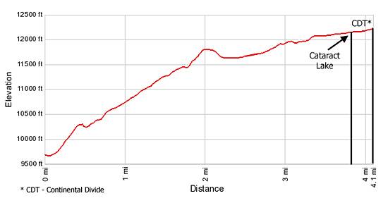
- Elevation: 9,630-ft. - 12,200-ft.
- Elevation Gain: 2,570-ft.
- Difficulty: moderate-strenuous
- Trail Highlights: See Trail Intro
- Basecamp(s): Lake City
- Region: Southwest Colorado
Beginning in dense woods the trail passes cascades and waterfalls along Cataract Creek, travels through beautiful alpine meadows and visits a scenic alpine lake on its way to the Continental Divide.
Trailhead to Cataract Lake and the Continental Divide
Just beyond the trailhead parking area the trail up Cataract Gulch crosses Cottonwood Creek on a bridge and then begins a steep ascent on switchbacks through dense stands of spruce-fir forest. As you climb the trail crosses Cataract Creek five times without the aid of bridges. Generally these crossing are not a problem although you should be prepared to get your feet wet.
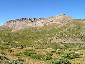
During the first 2.0-miles of the hike the trail gains over 2,000-ft. Waterfalls and cascades along Cataract Creek, spectacular displays of wildflowers and an old miner’s cabin will help divert your attention from the steep climb. Be sure to turn around when you get to openings in the trees for nice views of Sunshine Peak (14,001-ft.), located to the north (down canyon) across the Lake Fork Valley.
At 2.0 miles the grade eases a bit as the trail climbs through meadows with patches of low lying shrubs. Along this section of the trail views open to Half Peak (13,841-ft.) rising to the west of the trail.
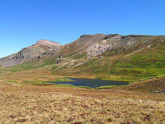
After 3.0 miles the trail becomes easier, ascending on gentle grades through alpine meadows past a few small tarns to Cataract Lake (12,100-ft.) at 3.8 miles. The lake lies in a pretty meadow decorated with small patch of scrub willows just below the Continental Divide.
To reach the Continental Divide, follow the trail along the east side of the lake. At the head of the lake the trail curves to the right (southwest), reaching the Divide (12,200-ft.) at 4.1 miles. From the divide views stretch southeast down the West Lost Creek Valley and beyond.
The divide is the turnaround point for day hikers. It is possible to connect with the Cuba Gulch Trail by going west cross country. A map is essential for finding the right route across the 2.0 miles of open tundra to the head of Cuba Gulch. This loop, totaling about 14 miles, is best done as an overnight backpacking trip.
Elevation Profile
| Buy the BookThis opinionated guide includes all the hikes in the Ouray, Telluride, Silverton and Lake City sections of the website plus info on local services and nearby attractions. |
Driving Directions
Driving Directions from Lake City: From Lake City take Highway 149 south for 2.5 miles. Turn right onto CR 30,the road to Lake San Cristobal. Follow the paved road approximately 4 miles then continue on the dirt road for about 8.3 miles. At the fork in the road turn left on CR 35 toward Sherman and drive 1.4 miles. A sign marks the trailhead on the left (south) side of the road.
Trail Resources
Trail Intro / Trail Photo Gallery / Trail Map
Basecamp(s) Information:
Lake City
Region Information:
Southwest Colorado
Other Hiking Regions in:
Colorado