Details: Tower Arch 
Distance: 2.4 - 5.7 miles (round trip)
Arches National Park, near Arches in Southeast Utah
Hike Facts
- Distance: 2.4 - 5.7 miles (round trip)
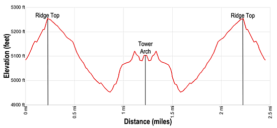
- Elevation: 5,070-ft. - 5,255-ft.
- Elevation Gain: 305-ft.
- Difficulty: moderate
- Trail Highlights: See Trail Intro
- Basecamp(s): Arches / Moab
- Region: Southeast Utah
An off-the-beaten-path hike in the Klondike Bluffs area of Arches National Park leads through a secluded valley ringed by a wonderland of deep-red rock formations before reaching Tower Arch, an immense span with lovely views of the La Sal Mountains.
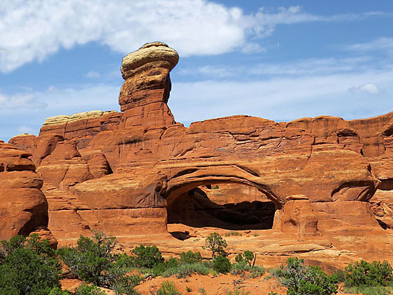
Tower Arch
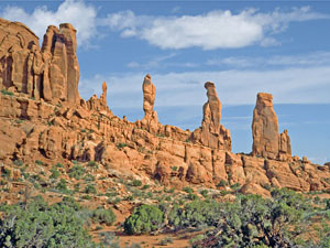
This trailhead is located 8.0 miles down the Salt Valley Road, an unpaved track in the Klondike Bluffs section of the park. (See driving directions below). From the trailhead kiosk the hike ascends 200-ft. up a rocky hillside to the top of a ridge. The ridge top enjoys fine views of the Salt Valley and distant vistas of Devil’s Garden. The trail now descends on moderate grades, traveling through a photogenic valley lined by deep-red fins, towers and spires set atop rocky cliffs. Klondike Bluffs rise to the north. Near the end of the descent the Marching Men, a series of four rock spires standing atop a huge eroded sandstone fine, come into view to the left (south).
At 0.9 miles the descent ends and the trail now climbs a sandy hill. As you climb, the trail curves north at 1.0-mile and then wanders through sandstone fins. Walking becomes easier as the path crests the hill and the surfaces changes to dirt/slickrock. You are now surrounded by fins and eroded sandstone formations. Watch for Parallel Arch, an interesting double arch, which appears on the right after you drop down a short expanse of slickrock. This formation is easy to miss. Don’t fret if you miss the arch, it is much more apparent on the return trip to your vehicle.
Beyond Parallel Arch pass a signed trail heading west to the 4WD trailhead. Immense Tower Arch is now in view. Our trail continues straight ahead for a short distance to a viewpoint in front of the stunning 92-wide span. Its namesake tower rises behind and to the north of the arch.
A short scramble up slickrock ledges leads to the inside of the arch where you are treated to terrific views of the La Sal Mountains to the east. Look for Alex Ringhoffer’s inscription near the base of the arch. Ringhoffer was impressed with the beauty of the Klondike Bluffs area and became one of the prime advocates lobbying for the establishment of Arches as a National Park.
When you are done exploring the area around the Arch, retrace your steps to the trailhead for a 2.4-miles RT hike. Alternatively, take the trail to the 4WD trailhead and then follow the 4WD roads back to the Klondike Bluff Road and your vehicle. This alternative adds 3.2 miles to the hike, creating a 5.6 mile loop. You should not attempt the loop on a hot day or if you are not carrying adequate water.
Elevation Profile
Driving Directions
From Moab, UT: From Center Street and Main Street/US 191 in Moab, head north on Main Street/US 191 N for 4.6 miles and then turn right on the Arches Entrance Road. Pass thru the kiosk where you pay your entrance fee. A short distance beyond the kiosk is the right turn for the Visitor Center (0.7 miles from the entrance). The Visitor Center is a good place to see exhibits on the park, obtain information and check on current conditions.
Beyond the Visitor Center follow the road, now called the Arches Scenic Drive, for 16.4 miles and turn left onto the Salt Valley Road, an unpaved road located a short distance beyond the trailhead for Sand Dune Arch. Follow the Salt Valley road for 7.2 miles and then branch left onto the Klondike Bluff Road. Drive one mile to the end of the road and the trailhead for Tower Arch.
Note: The Salt Valley Road may be rough and sandy in places. The route is impassable when wet. Stop at the Visitor Center to obtain information on current road conditions before setting out on this hike.
Trail Resources
Trail Intro / Trail Photo Gallery / Trail Map
Basecamp(s) Information:
Arches / Moab
Region Information:
Southeast Utah
Other Hiking Regions in:
Utah